Hawk Mountain Trail System

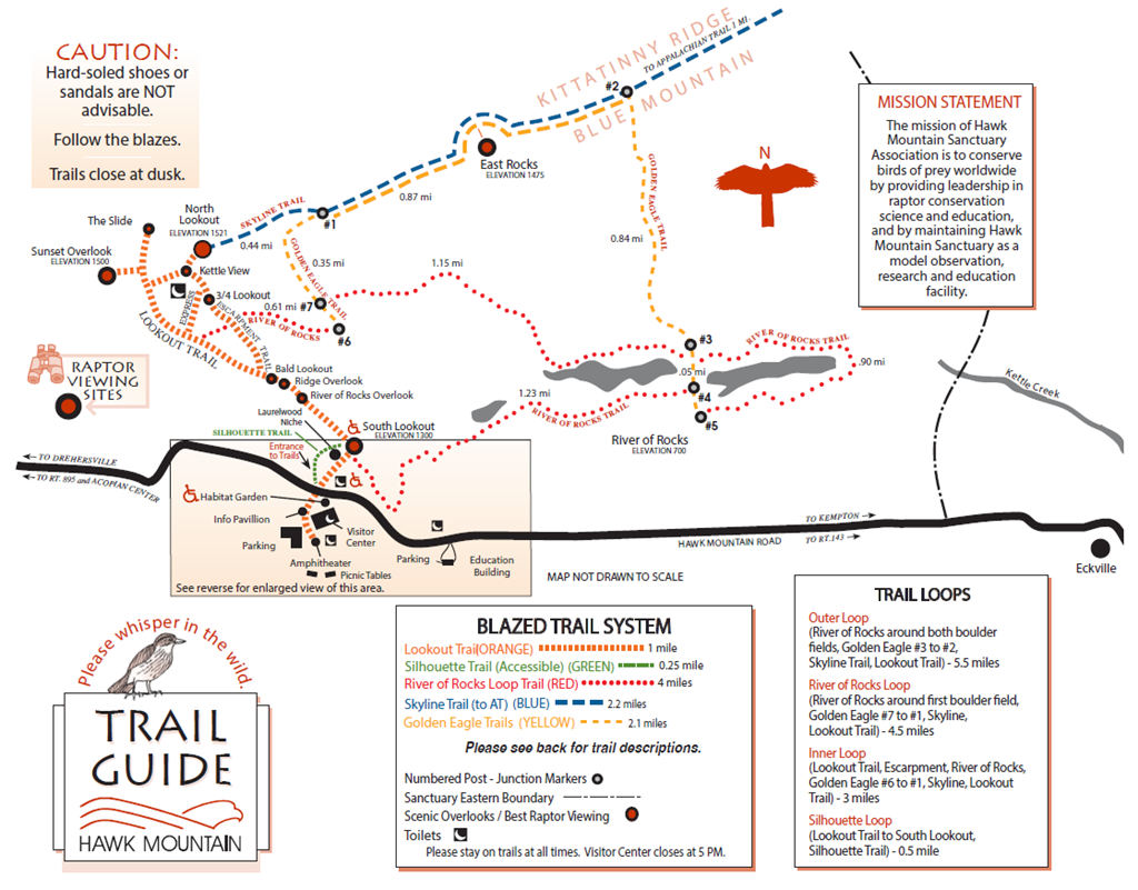
Hawk Mountain Trail Map
DownloadTrail Descriptions
To access all trails, follow the walkway from the Visitor Center and cross Hawk Mountain Road to begin at the entrance. TRAILS ARE ROCKY AND UNGRADED except the walk to South Lookout.
175 yards from Entrance Gate, the trail to this lookout is groomed and can be accessed by motorized wheelchairs as well as by manual wheelchairs with assistance. Below South Lookout is the River of Rocks, an Ice-Age boulder field. An observer-interpreter is stationed daily at South Lookout September through early November.
Vertical rise: 300 feet. The quickest trail to North Lookout (NLO) is the Lookout Trail. Alternatives are the Express Route, a steep shortcut often used for return descent, and the rocky difficult Escarpment Trail that follows the ridge edge. The North Lookout consists of large boulders that require rock scrambling to traverse.
This trail is wheelchair accessible and offers an alternative route to South Lookout. It is 900 feet long, and the grade does not exceed 8.3 %.
Vertical descent: 600 feet. Begin this trail by turning right just before South Lookout after 0.3 mile on the Lookout Trail. Allow 3-4 hours to complete loop. The loop trail is very rough and rocky. Several unmarked trails cross this trail; pay extra attention and follow the RED blazes.
This rugged, ridgetop trail follows the spine of the Kittatinny eastward and down over North Lookout, crosses East Rocks (a scenic overlook), and meets the Appalachian Trail 2.5 miles from NLO. East Rocks is a good place to see migration. This difficult trail includes 4-point rock scrambling and is recommended only for experienced hikers—just off NLO is a 30-foot vertical descent. The trail is accessible via part of the Lookout Trail, Golden Eagle Trail, and River of Rocks Trail.
Vertical rise: 800 feet. This trail connects the Skyline Trail (blue) with the River of Rocks Trail (red) and follows a steep grade.
Trail Loops
Distance: 5.5 miles
Begin with the River of Rocks trail around both boulder fields, turn right onto Golden Eagle at junction #3 and hike .84 mi to junction #2, turn left onto Skyline Trail and hike to North Lookout. Take the Lookout Trail back down to the Visitor Center.
Distance: 4.5 miles
Begin with the River of Rocks trail and go around the first boulder field, and continue 1.15 miles to junction # 7 on the Golden Eagle trail. Continue on the Golden Eagle trail to junction #1, turn left onto Skyline Trail, and hike to North Lookout. Take the Lookout Trail back down to the Visitor Center.
Distance: 3 miles
Hike up the Lookout Trail pass Bald Overlook, then take a slight right onto the Escarpment Trail. Half way up, turn right onto the River of Rocks trail: look for the red blazes. At junction #6, turn left onto the Golden Eagle trail and hike a third of a mile to junction #1. Turn left onto Skyline Trail and hike to North Lookout. Take the Lookout Trail back down to the Visitor Center.
Distance: 0.5 mile
After passing through the Entrance Gate, take a slight left onto the ADA Accessible Silhouette Trail. Continue until you reach South Lookout. Take the Lookout Trail back down to the Visitor Center. This entire loop is wheelchair accessible.